
Tell your friends about this item:
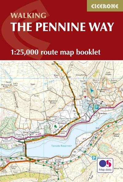
Pennine Way Map Booklet: 1:25,000 OS Route Mapping
Paddy Dillon
Our customers say:

Add to your iMusic wish list
Pennine Way Map Booklet: 1:25,000 OS Route Mapping
Paddy Dillon
Map of the 270 miles (435km) Pennine Way National Trail, between Edale in the Peak District and Kirk Yetholm in the Scottish Borders. This booklet is included with the Cicerone guidebook to the trail, and shows the full route on OS 1:25,000 maps. This popular long-distance route typically takes three weeks to complete.
136 pages, 120 pages of OS 1:25K mapping + map legend
| Media | Books Paperback Book (Book with soft cover and glued back) |
| Released | August 5, 2018 |
| ISBN13 | 9781852849078 |
| Publishers | Cicerone Press |
| Pages | 136 |
| Dimensions | 179 × 123 × 10 mm · 174 g |
Show all
More by Paddy Dillon
![Cover for Paddy Dillon · The Cleveland Way and the Yorkshire Wolds Way: NATIONAL TRAILS: The North York Moors, Yorkshire Wolds and Yorkshire Coast (Paperback Book) [3 Revised edition] (2024)](https://imusic.b-cdn.net/images/item/original/211/9781786312211.jpg?paddy-dillon-2024-the-cleveland-way-and-the-yorkshire-wolds-way-national-trails-the-north-york-moors-yorkshire-wolds-and-yorkshire-coast-paperback-book&class=scaled&v=1693309737)
![Cover for Paddy Dillon · The Cleveland Way Map Booklet: 1:25,000 OS Route Mapping (Paperback Book) [2 Revised edition] (2024)](https://imusic.b-cdn.net/images/item/original/228/9781786312228.jpg?paddy-dillon-2024-the-cleveland-way-map-booklet-1-25-000-os-route-mapping-paperback-book&class=scaled&v=1695660772)
![Cover for Paddy Dillon · South West Coast Path Map Booklet - Vol 1: Minehead to St Ives: 1:25,000 OS Route Mapping (Paperback Book) [2 Revised edition] (2024)](https://imusic.b-cdn.net/images/item/original/181/9781786312181.jpg?paddy-dillon-2024-south-west-coast-path-map-booklet-vol-1-minehead-to-st-ives-1-25-000-os-route-mapping-paperback-book&class=scaled&v=1695051792)
![Cover for Paddy Dillon · Walking Glyndwr's Way: A National Trail through mid-Wales (Paperback Book) [3 Revised edition] (2024)](https://imusic.b-cdn.net/images/item/original/290/9781786311290.jpg?paddy-dillon-2024-walking-glyndwr-s-way-a-national-trail-through-mid-wales-paperback-book&class=scaled&v=1692641364)
![Cover for Paddy Dillon · Walking the South West Coast Path: National Trail From Minehead to South Haven Point (Paperback Book) [3 Revised edition] (2023)](https://imusic.b-cdn.net/images/item/original/682/9781786310682.jpg?paddy-dillon-2023-walking-the-south-west-coast-path-national-trail-from-minehead-to-south-haven-point-paperback-book&class=scaled&v=1618498958)
![Cover for Paddy Dillon · Walking on Madeira: 60 mountain and levada routes on Madeira and Porto Santo (Paperback Book) [3 Revised edition] (2023)](https://imusic.b-cdn.net/images/item/original/552/9781852848552.jpg?paddy-dillon-2023-walking-on-madeira-60-mountain-and-levada-routes-on-madeira-and-porto-santo-paperback-book&class=scaled&v=1647822359)
![Cover for Paddy Dillon · South West Coast Path Map Booklet - Vol 3: Plymouth to Poole: 1:25,000 OS Route Mapping (Paperback Book) [2 Revised edition] (2023)](https://imusic.b-cdn.net/images/item/original/006/9781786312006.jpg?paddy-dillon-2023-south-west-coast-path-map-booklet-vol-3-plymouth-to-poole-1-25-000-os-route-mapping-paperback-book&class=scaled&v=1679479665)
![Cover for Paddy Dillon · Walking on Guernsey: 25 routes including the Guernsey Coastal Walk, Alderney, Sark and Herm (Paperback Book) [3 Revised edition] (2023)](https://imusic.b-cdn.net/images/item/original/306/9781786311306.jpg?paddy-dillon-2023-walking-on-guernsey-25-routes-including-the-guernsey-coastal-walk-alderney-sark-and-herm-paperback-book&class=scaled&v=1673724734)
![Cover for Paddy Dillon · Trekking in Mallorca: GR221 - The Drystone Route through the Serra de Tramuntana (Paperback Book) [2 Revised edition] (2023)](https://imusic.b-cdn.net/images/item/original/507/9781852848507.jpg?paddy-dillon-2023-trekking-in-mallorca-gr221-the-drystone-route-through-the-serra-de-tramuntana-paperback-book&class=scaled&v=1647822355)
![Cover for Paddy Dillon · Trekking in Greenland - The Arctic Circle Trail: From Kangerlussuaq to Sisimiut (Paperback Book) [2 Revised edition] (2023)](https://imusic.b-cdn.net/images/item/original/672/9781852849672.jpg?paddy-dillon-2023-trekking-in-greenland-the-arctic-circle-trail-from-kangerlussuaq-to-sisimiut-paperback-book&class=scaled&v=1647822411)
![Cover for Paddy Dillon · Walking on Tenerife: 45 walks including El Teide and GR 131 (Paperback Book) [3 Revised edition] (2023)](https://imusic.b-cdn.net/images/item/original/699/9781786310699.jpg?paddy-dillon-2023-walking-on-tenerife-45-walks-including-el-teide-and-gr-131-paperback-book&class=scaled&v=1645977608)
![Cover for Paddy Dillon · Walking in County Durham: 40 walking routes exploring Pennine moors, river valleys and coastal paths (Paperback Book) [5 Revised edition] (2022)](https://imusic.b-cdn.net/images/item/original/375/9781786311375.jpg?paddy-dillon-2022-walking-in-county-durham-40-walking-routes-exploring-pennine-moors-river-valleys-and-coastal-paths-paperback-book&class=scaled&v=1650458820)
![Cover for Paddy Dillon · Trekking the GR20 Corsica: The High Level Route: Guidebook and map booklet (Paperback Book) [5 Revised edition] (2022)](https://imusic.b-cdn.net/images/item/original/675/9781786310675.jpg?paddy-dillon-2022-trekking-the-gr20-corsica-the-high-level-route-guidebook-and-map-booklet-paperback-book&class=scaled&v=1639650677)
![Cover for Paddy Dillon · Walking the Wales Coast Path: Llwybr Arfordir Cymru (Paperback Book) [2 Revised edition] (2022)](https://imusic.b-cdn.net/images/item/original/668/9781786310668.jpg?paddy-dillon-2022-walking-the-wales-coast-path-llwybr-arfordir-cymru-paperback-book&class=scaled&v=1637076368)
![Cover for Paddy Dillon · Walking in the Isles of Scilly: 11 walks and 4 boat trips exploring the best of the islands (Paperback Book) [5 Revised edition] (2022)](https://imusic.b-cdn.net/images/item/original/047/9781786311047.jpg?paddy-dillon-2022-walking-in-the-isles-of-scilly-11-walks-and-4-boat-trips-exploring-the-best-of-the-islands-paperback-book&class=scaled&v=1606971158)
![Cover for Paddy Dillon · The Great Glen Way: Fort William to Inverness Two-way trail guide (Paperback Book) [2 Revised edition] (2022)](https://imusic.b-cdn.net/images/item/original/019/9781852848019.jpg?paddy-dillon-2022-the-great-glen-way-fort-william-to-inverness-two-way-trail-guide-paperback-book&class=scaled&v=1647822335)
![Cover for Paddy Dillon · The Pennine Way: From Edale to Kirk Yetholm (Paperback Book) [4 Revised edition] (2022)](https://imusic.b-cdn.net/images/item/original/061/9781852849061.jpg?paddy-dillon-2022-the-pennine-way-from-edale-to-kirk-yetholm-paperback-book&class=scaled&v=1647822382)
![Cover for Paddy Dillon · Walking on Jersey: 24 routes and the Jersey Coastal Walk (Paperback Book) [3 Revised edition] (2021)](https://imusic.b-cdn.net/images/item/original/030/9781786311030.jpg?paddy-dillon-2021-walking-on-jersey-24-routes-and-the-jersey-coastal-walk-paperback-book&class=scaled&v=1617934257)
![Cover for Paddy Dillon · Cumbria Way (2 ed) (Paperback Book) [Revised with route updates edition] (2021)](https://imusic.b-cdn.net/images/item/original/039/9781913817039.jpg?paddy-dillon-2021-cumbria-way-2-ed-paperback-book&class=scaled&v=1629192851)
![Cover for Paddy Dillon · The North York Moors: 50 walks in the National Park (Paperback Book) [2 Revised edition] (2021)](https://imusic.b-cdn.net/images/item/original/511/9781852849511.jpg?paddy-dillon-2021-the-north-york-moors-50-walks-in-the-national-park-paperback-book&class=scaled&v=1647822405)
![Cover for Paddy Dillon · The National Trails: 19 Long-Distance Routes through England, Scotland and Wales (Paperback Book) [2 Revised edition] (2021)](https://imusic.b-cdn.net/images/item/original/883/9781852847883.jpg?paddy-dillon-2021-the-national-trails-19-long-distance-routes-through-england-scotland-and-wales-paperback-book&class=scaled&v=1647822332)
![Cover for Paddy Dillon · Walking in the North Pennines: 50 Walks in England's remotest Area of Outstanding Natural Beauty (Paperback Book) [3 Revised edition] (2021)](https://imusic.b-cdn.net/images/item/original/054/9781852849054.jpg?paddy-dillon-2021-walking-in-the-north-pennines-50-walks-in-england-s-remotest-area-of-outstanding-natural-beauty-paperback-book&class=scaled&v=1647822382)
![Cover for Paddy Dillon · Walking on La Gomera and El Hierro: 45 day walks and treks for all abilities (Paperback Book) [3 Revised edition] (2020)](https://imusic.b-cdn.net/images/item/original/415/9781852848415.jpg?paddy-dillon-2020-walking-on-la-gomera-and-el-hierro-45-day-walks-and-treks-for-all-abilities-paperback-book&class=scaled&v=1647822351)
![Cover for Paddy Dillon · Walking on Gran Canaria: 45 day walks including five days on the GR131 coast-to-coast route (Paperback Book) [2 Revised edition] (2020)](https://imusic.b-cdn.net/images/item/original/545/9781852848545.jpg?paddy-dillon-2020-walking-on-gran-canaria-45-day-walks-including-five-days-on-the-gr131-coast-to-coast-route-paperback-book&class=scaled&v=1647822358)
![Cover for Paddy Dillon · Walking on Malta: 33 walks on the Mediterranean islands of Malta, Gozo and Comino (Paperback Book) [3 Revised edition] (2019)](https://imusic.b-cdn.net/images/item/original/224/9781852848224.jpg?paddy-dillon-2019-walking-on-malta-33-walks-on-the-mediterranean-islands-of-malta-gozo-and-comino-paperback-book&class=scaled&v=1454938679)
![Cover for Paddy Dillon · Walking and Trekking in Iceland: 100 days of walking and multi-day treks (Paperback Book) [2 Revised edition] (2019)](https://imusic.b-cdn.net/images/item/original/057/9781852848057.jpg?paddy-dillon-2019-walking-and-trekking-in-iceland-100-days-of-walking-and-multi-day-treks-paperback-book&class=scaled&v=1647822336)
![Cover for Paddy Dillon · Walking on La Palma: Including the GR130 and GR131 long-distance trails (Paperback Book) [2 Revised edition] (2019)](https://imusic.b-cdn.net/images/item/original/538/9781852848538.jpg?paddy-dillon-2019-walking-on-la-palma-including-the-gr130-and-gr131-long-distance-trails-paperback-book&class=scaled&v=1647822358)
Others have also bought

![Cover for Michael Strunge · Samlede Strunge (Sewn Spine Book) [2nd edition] (2019)](https://imusic.b-cdn.net/images/item/original/340/9788702293340.jpg?michael-strunge-2019-samlede-strunge-sewn-spine-book&class=scaled&v=1572433621)
![Cover for Helle Benedikte Neigaard · Strikkede klude (Sewn Spine Book) [1st edition] (2016)](https://imusic.b-cdn.net/images/item/original/871/9788740610871.jpg?helle-benedikte-neigaard-2016-strikkede-klude-sewn-spine-book&class=scaled&v=1464667516)
![Cover for Claus Dalby · SMÅ HAVER - store drømme (Bound Book) [1st edition] (2019)](https://imusic.b-cdn.net/images/item/original/750/9788771393750.jpg?claus-dalby-2019-smaa-haver-store-droemme-bound-book&class=scaled&v=1542205903)
![Cover for Kev Reynolds · Walking in Austria: 101 routes - day walks, multi-day treks and classic hut-to-hut tours (Paperback Book) [2 Revised edition] (2023)](https://imusic.b-cdn.net/images/item/original/590/9781852848590.jpg?kev-reynolds-2023-walking-in-austria-101-routes-day-walks-multi-day-treks-and-classic-hut-to-hut-tours-paperback-book&class=scaled&v=1647822360)

![Cover for Dawkins, Richard (Emeritus Fellow of New College, Oxford.) · The Selfish Gene: 40th Anniversary edition - Oxford Landmark Science (Paperback Book) [4 Revised edition] (2016)](https://imusic.b-cdn.net/images/item/original/607/9780198788607.jpg?dawkins-richard-emeritus-fellow-of-new-college-oxford-2016-the-selfish-gene-40th-anniversary-edition-oxford-landmark-science-paperback-book&class=scaled&v=1466373546)
![Cover for Jakob Kærgaard · Bedre sex, mand! (Sewn Spine Book) [1st edition] (2022)](https://imusic.b-cdn.net/images/item/original/783/9788772165783.jpg?jakob-kaergaard-2022-bedre-sex-mand-sewn-spine-book&class=scaled&v=1659798785)
See all of Paddy Dillon ( e.g. Paperback Book , Book , Sewn Spine Book and Spiral Book )