Tell your friends about this item:
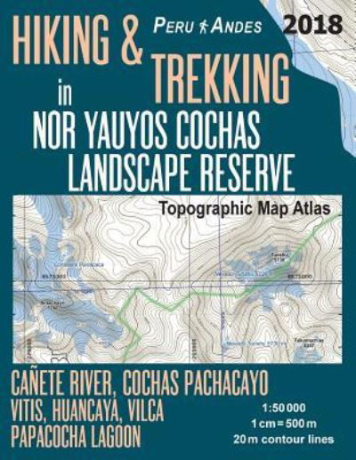
Hiking & Trekking in Nor Yauyos Cochas Landscape Reserve Peru Andes Topographic Map Atlas Canete River, Cochas Pachacayo, Vitis, Huancaya, Vilca, Papacocha Lagoon 1
Sergio Mazitto
Ordered from remote warehouse
Our customers say:

Hiking & Trekking in Nor Yauyos Cochas Landscape Reserve Peru Andes Topographic Map Atlas Canete River, Cochas Pachacayo, Vitis, Huancaya, Vilca, Papacocha Lagoon 1
Sergio Mazitto
Updated 2018 edition. Detailed topographic map 1:50.000 & 20 meter contours for hiking and trekking, printed as an atlas book (with overlapping pages).
Covers the Nor Yauyos Cochas Landscape Reserve (RPNYC) located in the high and middle basin of the Cañete River, protecting one of the most beautiful landscapes of High Andes in Peru. Covers the tourist towns of Vitis, Huancaya, Vilca, Laraos, etc. inside the reserve as well as Quinches, Yauyos and others outside.
20 meter contour lines, road network, trails & paths, transportation, food, campsites, shelters, guest houses & hotels. Mercator projection with both UTM and WGS84 coordinate grids.
The map scale of 1:50000 (1 cm = 500 meters) provides a wealth of detail while keeping low the weight of the atlas itself. The large page format of 8.5x11in minimizes page count and along with an overlapping map design allows for comfortable navigation.
The details included in the topographic maps of this atlas were specifically selected to be useful for trekkers, hikers and walkers of all interests, and make it easy to plan and enjoy both short excursions and hikes as well as long multi-day adventures along the main marked routes and/or adjacent trails and paths, which are also shown on the maps.
With this ultralight atlas you will always have a detailed, reliable, information-rich, battery-independent, shatter-proof map for your adventure.
| Media | Books Paperback Book (Book with soft cover and glued back) |
| Released | February 23, 2018 |
| ISBN13 | 9781985813069 |
| Publishers | Createspace Independent Publishing Platf |
| Pages | 46 |
| Dimensions | 216 × 280 × 3 mm · 172 g |
| Language | English |